The Ridge That Sends Rain in Two Directions
A watershed divide separates neighbouring catchments. Learn how to trace its boundary on a contour map and spot where terrain or drains complicate it.
The common mistake with a watershed divide is to treat it as a wall along a ridge. That can make a map seem more certain than the land: the boundary separates catchments, but it does not hold water in place. A watershed divide marks the high ground between areas that drain towards different outlets.
Say you are checking an invented map of two neighbouring valleys. A contour map shows a spur between them, a saddle where the high ground dips, and streams running away on either side. Tracing the divide helps identify which catchment includes a field, road or wetland—and which downstream river may be connected to it.
Catchments and divides
A catchment is the area of land whose water drains to a particular outlet. A watershed divide marks the boundary between adjacent catchments. It often follows high ground, but the line may turn around spurs and cross saddles; it is not always the most dramatic ridge or the highest summit in the wider landscape.
For a first estimate, use a topographic map with contour lines and mapped streams. Contours form closed shapes around hills and point towards lower ground in valleys. Trace the high ground between neighbouring stream valleys, then check that slopes on opposite sides lead towards different channels. Treat the result as an interpretation, not a visible boundary laid across the land.
Tracing a map boundary
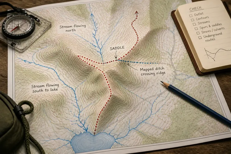
Use a paper topographic map and pencil, or a mapping app that displays contours, streams and terrain. Work from the outlet upstream: identify the river, lake or other receiving water body, follow its tributary network, then mark the high ground separating that network from its neighbours.
- Check the outlet and its named channel; if the channel network leads to the outlet, trace its tributaries, but if it leads elsewhere, start with the correct receiving water body.
- Check where contour lines form valley shapes around mapped streams; if the contours support the stream direction, continue upstream, but if they conflict, inspect a more detailed map.
- Check the high ground between adjacent valleys; if slopes fall towards different stream networks, mark a provisional divide, but if the ground is broad or nearly level, leave the line uncertain.
- Check spurs and saddles where the boundary changes direction; if contours show a continuous ridge or dip between valleys, follow that shape, but if the map is unclear, compare another terrain layer.
- Check roads, culverts and drainage ditches shown on the map; if they redirect surface water across the apparent divide, note the altered route, but if their direction is unknown, do not assume the natural boundary explains it.
- Check whether a stream disappears underground or enters a mapped drain; if a subsurface route is documented, account for it, but if it is not, mark that part of the catchment as uncertain.
Imagine an invented map with a named stream flowing south to a lake, a neighbouring stream flowing north, and a rounded ridge between their valleys. Starting at the lake, you trace the southern stream upstream and mark the high ground separating it from the northern network. At a saddle, the contours dip but the valleys still fall away on opposite sides, so you continue the provisional boundary across it. A mapped ditch then crosses the ridge towards the southern stream. You note that this may alter local surface drainage, but, without evidence about its connection, leave the natural divide marked separately from the ditch’s route.
Where boundaries get complicated
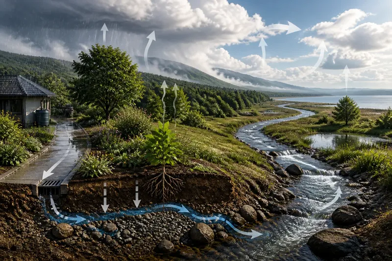
Contour maps describe surface shape, not every route water can take. Rain may soak into soil and move underground; springs can return it to the surface elsewhere. Culverts, roadside drains, canals and ditches may also redirect surface flow. A mapped divide is therefore most useful when its assumptions and uncertain sections are visible.
Keep natural terrain and built drainage distinct in your notes. A road crossing a ridge does not by itself change the catchment, while a drain that carries water across the ridge may alter local routing. Check map symbols and available local drainage information before treating a feature as a connection between catchments.
For a real site, compare the map with visible channels and drainage structures from a safe public place. Do not enter culverts, private land or fast-flowing water to check a route. If the boundary matters for planning, land management or a formal decision, consult a qualified local professional or the relevant mapping authority.
Questions about divides?
Does every ridge mark a watershed divide?
Many ridges separate neighbouring catchments, but a ridge’s appearance or name is not enough to establish the boundary. Check the surrounding valleys and the direction of drainage on a contour map.
Can water cross a divide?
Groundwater, culverts and human-made channels can carry water across or beneath apparent high ground. Note those routes separately from the surface divide unless reliable local information shows how they connect.
Where does a catchment end?
A catchment ends at the outlet where its drainage network meets a receiving water body, such as a larger river or lake. Its boundary encloses the land draining towards that outlet, not just the channel itself.
Can a map show the divide?
A topographic map can show a likely divide through its contours, valleys and streams. The line remains an interpretation, especially where the land is flat or constructed drainage changes the route.
Using the boundary
A divide is a practical way to understand which places share a drainage network. It can connect slopes, roads, fields and wetlands to the same downstream waters, while separating them from a neighbouring catchment. The boundary may be subtle, so keep uncertain sections visible rather than drawing a falsely precise line.
When reading a watershed divide, start with the receiving water body, trace its mapped channels upstream, and use the high ground between valleys to sketch the catchment edge. Then check for drains, culverts and underground routes that could complicate the picture. That distinction makes a map more useful: it shows both the natural separation and the places where local infrastructure may change it.