Why Rivers Bend Instead of Running Straight
Why rivers bend instead of running straight: learn to read banks, flow and sediment, and distinguish visible change from a misleading map or snapshot.
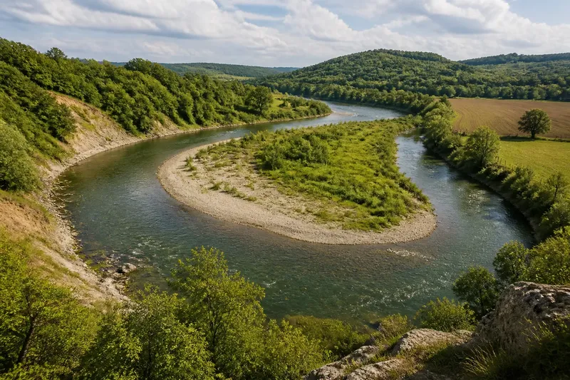
The common mistake is to treat a river bend as a fixed feature. That can lead you to mistake a single patch of exposed soil or a pale bar for proof that the whole channel is shifting. Why rivers bend instead of running straight becomes clearer when you compare the flow, banks and sediment across a reach.
Start with the valley
Choose a safe public viewpoint where you can see both banks, such as a bridge or riverside path. Keep back from the edge: a bank may be undercut or slippery even when the water looks calm. Do not enter the channel to inspect it.
First note how much room the river has. Steep valley sides, bedrock, walls or levees can confine a channel. A broad floodplain gives it more space to move sideways. These boundaries limit possible movement, but they do not explain every detail of a bend.
Look at the bank material and cover. Exposed rock, gravel, sand, mud, roots and vegetation offer different resistance to flowing water. A hard boundary may hold its position while a softer patch nearby wears away. Note what you see before deciding what it means.
Read flow through a bend
Water does not move at an even speed across a channel. Depth, bed roughness and the shape of the banks affect its path. As flow follows a curve, the faster current commonly runs closer to the outside bank, where it can scour the bed or wear at the bank.
On the inside of a curve, slower flow can leave some of its transported sand or gravel behind. This deposit may form a shallow bar. The bar and the channel then influence each other: the deposit changes the route of the water, while later flows can reshape or remove it.
Do not treat the outer bank as an erosion zone and the inner bank as a permanent deposit zone. Water level, obstructions, bank strength and flow conditions can shift where erosion or deposition occurs. A pattern across the reach is more useful than one moment of ripples.
Track sediment movement
Rivers carry sediment in different ways. Fine particles can stay suspended in the water; coarser grains may roll, slide or hop along the bed. When flow loses energy, some material settles. When it gains force or strikes a vulnerable bank, erosion can add more sediment to the river.
This exchange links parts of a channel. A bank may release material that is carried downstream and deposited elsewhere. The outcome depends on the water’s force, the sediment available, the bank material and the space around the river. A bend can change shape without every part of it changing at once.
Say you are looking at an invented river bend beside a field. Your starting observation is a gravel patch on the inner bank and bare soil opposite it. You sketch both features from a safe public path, then check a dated aerial image from the same reach and record its season and scale. If the image also shows a differently placed bank edge, you note a possible change but leave its cause open; if the edge appears unchanged, you record no clear movement from this comparison. Either result is more careful than treating one visit as proof.
Compare maps and visits
Aerial photographs and satellite images can help you compare a channel over time. Use images that show the same reach clearly, and note their dates, scale and season. Water level, shadows, vegetation and image quality can make banks or bars appear different even when the channel has not shifted.
On a visit, sketch the curve and mark fixed landmarks such as a bridge or a large rock. Record the viewpoint, date, visible bank condition and any obstruction that might redirect flow. At a later visit, use the same viewpoint where practical and compare observations before offering an explanation.
Keep observation and interpretation separate. “Bare soil below the outer bank” describes something visible. “The river is moving towards the field” is an explanation that would need stronger evidence, such as a consistent difference between dated images.
What limits a river bend?
Bedrock, steep valley walls, road embankments, levees and retaining structures can hold a channel in place or narrow its route. A bridge or crossing may affect flow locally. A bank protected in one spot may still erode elsewhere, so inspect the whole reach rather than assuming a structure has stopped change everywhere.
Upstream conditions also matter. Tributaries can add water and sediment; bank collapse can supply new material. A bend is part of a larger drainage system, but its shape also reflects the local valley, bed and banks. Look at both scales without assuming that one visible feature tells the whole story.
Questions about river bends?
Does the outer bank always erode?
No. Stronger flow may reach the outside of a curve, but rock, roots, bank protection or a changing current can limit or shift erosion. Check the whole bend for fresh exposure rather than relying on its shape alone.
Why does a bar form inside a bend?
Slower flow can deposit some of the sediment it carries, building a shallow patch on the inner side. Later flows may move that material, so a bar’s presence does not by itself show that the channel is migrating.
Can a river become straighter?
Yes. A channel can change course naturally, and human works can also cut off, constrain or redirect it. A straighter line on a map does not reveal which process caused the change.
Do all rivers form large bends?
No. A confined valley, steep slope, resistant bed or limited sediment can produce a different channel form from a river crossing a broad floodplain. The available space and materials shape what curves can develop.
Make field notes useful
Use a notebook and a simple sketch rather than relying on memory. For each observation, decide what it can and cannot support:
- Record the date and public viewing point; if either is missing, use the next visit to establish both before comparing notes.
- Sketch the channel and mark inner and outer banks; if you cannot identify the curve clearly, widen the sketch to include the upstream and downstream reach.
- Note exposed soil, roots, vegetation and visible sediment; if a feature is hidden by water or plants, mark it as not observed rather than absent.
- Describe hard boundaries such as bedrock, walls or levees; if a boundary confines the channel, avoid interpreting nearby stability as evidence that the whole reach is fixed.
- Check an image’s date, scale and season before comparing it; if those details are unclear, treat the image as context, not evidence of movement.
- Compare bank edges against a fixed landmark; if the apparent difference persists across suitable records, note possible channel change, and if it does not, record the comparison as inconclusive.
Why rivers bend instead of running straight is not answered by one rule about fast water or settling sediment. The useful explanation combines the current’s path, the material it moves and the boundaries that shape the channel. When you revisit a bend, record what changed and what stayed the same before assigning a cause; that distinction makes your map comparison far more useful.